

The City We Might Become
Austin Beyond the City Limits


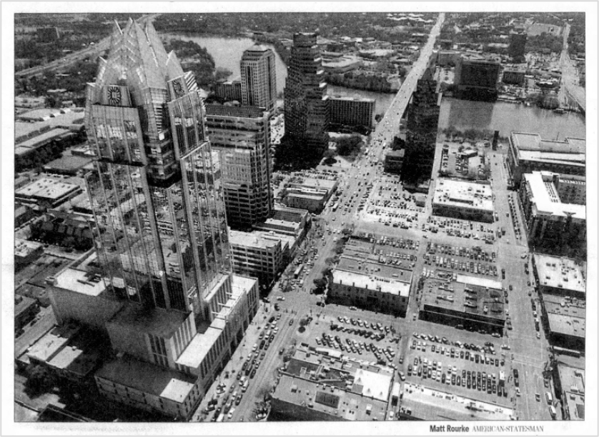
The Austin City Limits Music Festival, happening this week, is an annual opportunity to chart more than the biggest names in music. The festival’s east stage, set against the backdrop of the downtown skyline, has been witness to the city’s dramatic growth over the past twenty years. When I first visited Austin in 2012, there wasn’t much to look at downtown. There were a lot of low-rise structures, the stately capitol, a few legitimate skyscrapers—and a ton of parking lots and garages. Only around 8,000 people lived there—twice as many who lived downtown at the dawn of the millennium, but 20% less than in the 1950s—and it felt that way, underpopulated.
Today, more than 15,000 people live downtown, and many of the new towers under construction will deliver more condos and apartments. To a certain type of Austinite, the skyline is merely visual evidence of everything the city has lost, but those skyscrapers should more rightly be seen as symbols of the resilience and rebirth of downtown—and what made it possible.

Austin’s skyline is largely growing on a one-square-mile street grid first laid out in 1839 that has remained largely intact across nearly two centuries. The Waller Plan, named for its surveyor, plotted rights of way (i.e., streets), space for the state capitol and other civic buildings, several parks—and that’s it. The government auctioned off the rest of the land to the public, and the public built homes and commercial buildings within the grid. The city was not overly planned, the plots weren’t micromanaged, and a city was allowed to organically develop. The short blocks—generally less than 300 feet long—were easily walkable and created lots of corners and opportunities for connection and commerce. For the first few decades of its existence, downtown was Austin, and a bustling small town emerged on that grid.

The downtown grid gives the center city a distinct urban form that has facilitated its post-urban renewal renaissance. In The Death and Life of Great American Cities, Jane Jacobs explains why this type of grid has proven resilient nearly 200 years later. She identified four “indispensable” conditions for creating the “exuberant diversity” that fuels vibrant, successful streets: 1) a mix of uses, 2) short blocks with lots of opportunities for corners, 3) a mingling of variously aged buildings, and 4) density of people, including residents. Indeed, the parts of downtown that are most vibrant today meet all four conditions. It’s the single-use districts where nobody lives, like the office-heavy district around the capitol or the dead-by-daylight “Dirty Sixth” entertainment district, that lack the exuberant diversity and vibrant street life.
Surely Edwin Waller only intuited the possibilities and opportunities that his street grid would create for his nascent city. But it was fortuitous for his civic heirs, because today we live in a city that at street-level is an incredibly desirable place to live, work, and hang out. The newer, taller buildings fit into that footprint, bringing more people and more opportunities for commerce and connection to downtown’s streets.
The Waller Plan was planning done right.

Compare it to Austin’s most famous—or infamous—planning document, the 1928 Master Plan. While the 1928 Plan is best remembered for its segregationist policies, it contained far-reaching proposals for street design, public transit, land use, parks, cemeteries, and fire stations. The 1928 planners thought they were planning for the future, noting that “the present City Limits line is only temporary. The interests of the city extend far beyond this imaginary line.” They were right, and the parts of the plan that were dutifully adopted by the city leaders would impact future generations of Austinites far beyond those imaginary lines.
For instance, they recommended minimum lot sizes for single-family homes. In 1931, the city started requiring lots to be at least 3,000 square feet in size, then increased the requirement to 5,750 square feet in 1946. They also recommended a system of exclusionary zoning that favored single-family homes and segregated residential from commercial uses. These two policies would ensure that, as the city grew in the age of the automobile, the pattern of land use would follow one of auto-centric suburban sprawl, typified by strip malls on high-speed corridors and large-lot single-family homes on sidewalk-less streets. The planners were not explicitly calling for this pattern of development, but that’s what emerged: a city that abandoned the implicit principles behind its successful downtown grid. Over the decades, Austin would expand from its original, compact square mile into a 305-square-mile amoebic blob.

In reading the 1928 Plan, you can see the contours of the city that Austin might have become if the leaders of the time had made different choices. The plan’s maps show an existing grid-like urban pattern of development that extended beyond the square mile of downtown thanks to the city’s network of streetcars—Austin’s streetcar suburbs. The 1928 planners recommended expanding on that network by building out more streetcar lines and bus lines, recognizing a basic principle of transit-oriented development, that the “outlying extensions of a street car line or a bus line has to build up the territory it serves before it will earn a reasonable income on its investment.” In other words, transit requires density.
But the planners didn’t foresee that the tools of control they recommended—the large minimum lot sizes and exclusionary zoning—would, in combination with zealous city- and state-subsidized road construction for automobiles, reduce density across the city and completely undermine both the use-cases and economics of private transit. And so Austin discontinued its streetcar service in 1940, with the rail lines themselves pulled up for wartime scrap metal a couple years later.

But before then, by the mid-1920s when the above maps were produced, Austin had 23 miles of streetcar tracks serving a population of 40,000. One of those lines ended just a few blocks from my house and ran right past where my gym is downtown, near 6th and Congress—a journey that I (frustratingly) make by car each day. The 1928 planners plotted tantalizing extensions to the streetcar network that would have taken it beyond the city limits into unsettled fields that would, by proximity to downtown, become some of the most desired neighborhoods in the city even if accessible only by car.
Imagine, if the city leaders had followed the plan’s transit proposal, and not its zoning and lot size recommendations, what kind of city might Austin have become then?
Of course, the central city would likely have developed in entirely different ways. Neighborhoods in the urban core adjacent to downtown might have been allowed to organically evolve, rather than remaining frozen in time as suburbs of detached single-family homes. My single-family house with its yard just a half-mile from downtown might not exist at all, instead occupied by Brooklyn-esque townhomes or a small apartment building. Central neighborhoods might have been filled with a variety of “missing middle” housing types and neighborhood retail along a more expansive, walkable grid connected to a regular, reliable transit network that brought commuters to downtown instead of highways. There might have been more corners for connection and commerce, and more opportunities for people from central Austin to remain as land values and home prices inevitably rose.
But the forces of mid-century urban renewal, suburban subsidization, and urban highway construction were powerful, and it’s possible it still would have turned out the same: with a downtown that, by the advent of the millennium, had been drained of its vitality and paved over for parking lots.
In her novel The City We Became, N.K. Jemisen depicts cities as literally living, breathing things. They’re “organic, dynamic systems” that “are built to incorporate newness. But some new things become part of a city, helping it grow and strengthen—while some new things can tear it apart.” Though the novel is urban fantasy, there’s something intuitively real in her depiction:
This is the lesson: Great cities are like any other living things, being born and maturing and wearying and dying in their turn.
Waller’s grid allowed for downtown Austin to evolve over two centuries and persist through fifty years of anti-urban planning. The grid—that static, dead thing—is the bones of an organic, dynamic system that has accommodated new development, allowing the central city to grow and strengthen. The new elements of the 1928 Plan that were implemented—the racial segregation, the zoning, the minimum lot size requirements—they bled the urban core, stifled organic growth, tore apart communities, and weakened neighborhoods.
A good plan can sustain urban life across the centuries; a bad plan can kill a city.
Today in Austin, there are lots of plans in the works: a voter-approved light rail and rapid bus system to be built over decades; a plan to transform a 118-acre district just south of the lake from a wasteland of pavement and vacant buildings into a walkable, mixed-use neighborhood; a proposal to pedestrianize and “humanize” Congress Avenue, Austin’s “Main Street”; a plan to widen the interstate highway and a plan to build park-like “caps” to cover it. There are plans to build sidewalks and bike lanes, plans to bury power lines, and plans to continue chipping away at Austin’s cumbersome and restrictive land development code.
Which of the plans will allow the city to evolve? To address its housing affordability challenges? To build healthier, walkable, more inclusive neighborhoods? To create more opportunities for connection and commerce? To incorporate the new, and to grow and strengthen because of it? And which are too prescriptive, too top-down, too incremental, too limiting, too small-minded for the big challenges that face our city? Which could set the city on the wrong course? In other words, which are more like the Waller Plan and which are more like the 1928 Plan?
All of these plans are subject to the court of public opinion, much of it to lawsuits in the actual courts, and some of it to the availability of funding. Some plans may not survive public scrutiny, litigation, or financing; those that do are not guaranteed to succeed. Whether they survive, succeed, or fail, all could change the future of our city for generations.
Do we have the capacity to imagine that, the kind of city might we become—if we allow it?

Happy first birthday to City of Yes!
I published my very first essay on Substack exactly one year ago as part of the Roots of Progress Blog Building Intensive. All I knew, when I started, was that I wanted to write more frequently about the issues on my mind. City of Yes has become a catalog of my ruminations about how cities grow and evolve, an exploration of their life and death and rebirth, particularly at this turning point in urban history. I look forward to seeing how City of Yes evolves over the next year, and I’m extremely grateful that some 880+ of you have come along for the journey.
As ever, if you enjoy my work, the highest compliment you can give me is to share my writing with others. And if you really enjoy it, a paid subscription is always appreciated. Thank you so much for your support!
Congratulations to your one-year anniversary of writing City of Yes, Ryan. I have very much enjoyed following your work. You manage to cover important and at times difficult topics in a way that makes me eager to read each new issue. I’m excited to see what the next years bring!
I didn’t know you were part of the Root of Progress initiative! I met Jason 2 years ago, cool stuff!
Since you wrote “beyond” Austin City limits, I almost thought you were going to write about the suburbs. Have you spent much time exploring MPCs like Wolf Ranch, Whisper Valley, etc? I visited them and was impressed. Like many developers, my understanding is that MPCs generally want to develop higher-density housing there, too (ROI/acre), but town regulations or people complaining during town hall meetings often shut them down. If you wrote something related, I’d be happy to read it. Thanks!